


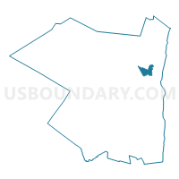
Voting District 190001, Ulster County, New York
About
Outline

Summary
| Unique Area Identifier | 637997 |
| Name | Voting District 190001 |
| County | Ulster County |
| State | New York |
| Area (square miles) | 6.24 |
| Land Area (square miles) | 6.08 |
| Water Area (square miles) | 0.16 |
| % of Land Area | 97.50 |
| % of Water Area | 2.50 |
| Latitude of the Internal Point | 41.95672130 |
| Longtitude of the Internal Point | -74.04184280 |
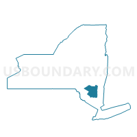
Maps

Graphs
Select a template below for downloading or customizing gragh for Voting District 190001, Ulster County, New York


Neighbors
Neighoring Voting District (by Name) Neighboring Voting District on the Map
- Voting District 050002 050003 050008, Ulster County, NY
- Voting District 060001, Ulster County, NY
- Voting District 070101, Ulster County, NY
- Voting District 070102, Ulster County, NY
- Voting District 070202, Ulster County, NY
- Voting District 070203 070603, Ulster County, NY
- Voting District 190002, Ulster County, NY
- Voting District 190005 190008, Ulster County, NY
- Voting District 190006 190013, Ulster County, NY
- Voting District 190007, Ulster County, NY
- Voting District 190010, Ulster County, NY
- Voting District 190011, Ulster County, NY
Top 10 Neighboring County Subdivision (by Population) Neighboring County Subdivision on the Map
- Kingston city, Ulster County, NY (23,893)
- Ulster town, Ulster County, NY (12,327)
- Hurley town, Ulster County, NY (6,314)
- Kingston town, Ulster County, NY (889)
Top 10 Neighboring Place (by Population) Neighboring Place on the Map
Top 10 Neighboring Unified School District (by Population) Neighboring Unified School District on the Map
Top 10 Neighboring State Legislative District Lower Chamber (by Population) Neighboring State Legislative District Lower Chamber on the Map
Top 10 Neighboring State Legislative District Upper Chamber (by Population) Neighboring State Legislative District Upper Chamber on the Map
Top 10 Neighboring 111th Congressional District (by Population) Neighboring 111th Congressional District on the Map
Top 10 Neighboring Census Tract (by Population) Neighboring Census Tract on the Map
- Census Tract 9512, Ulster County, NY (3,955)
- Census Tract 9515, Ulster County, NY (3,433)
- Census Tract 9514, Ulster County, NY (3,334)
- Census Tract 9524, Ulster County, NY (2,706)
- Census Tract 9516, Ulster County, NY (2,112)
- Census Tract 9523, Ulster County, NY (1,681)